Snowdon (known locally by its Welsh name Yr Wyddfa) is the highest mountain in Wales at 1085m (3,560ft) above sea level. It’s actually taller than any mountain in England too. In fact you’ll have to head up to the Scottish Highlands to find something bigger in the British Isles. Probably the most common question that gets asked around here is “Which is the easiest path up Snowdon?” So we’d like to share with you our guide to Snowdon’s main footpaths ranked in order of difficulty from the easiest to the most difficult.
Whilst there’s a small difference between the lengths of the paths (the Llanberis Path being the longest and the Pyg Track being the shortest) it’s not a huge amount so don’t look at distance alone. All the paths take roughly the same time with a faster walker being able to get up and down in around four hours but for most people, allow six or slightly longer if you’re walking with young children or in poor weather.
Please remember that the term ‘easy’ is somewhat subjective and what might be ‘easy’ for one person could be ‘challenging’ for another so when we say the Llanberis Path is the easiest, we’re certainly not describing it as easy.
IMPORTANT
Climbing Snowdon even on days when the weather looks fine can be dangerous and getting injured or losing your way is a very real possibility if you’re not suitably trained or have mountaineering experience. Please remember that Snowdon is the highest mountain in England and Wales and just because there are a number of footpaths to the top doesn’t mean it’s without risk. If you’re at all unsure of your abilities, we’d recommend joining one of our Climb Snowdon or Snowdon Sunrise adventures where one of our qualified and experienced mountain guides who are fully insured and hold up-to-date first aid certificates can guide you safely to the summit (and back down again!)
↓ EASIEST ↓
The Llanberis Path
At around nine miles (15km) this is not the shortest way up but does offer the most gradual climb making it a popular choice and our recommended route for first timers. Other than a couple of short, steeper sections the Llanberis Path is a nice uphill walk and suitable for most abilities. It’s pretty easy to follow and you’ve not much chance of falling off the side of the mountain! For much of the route the path follows the Snowdon Mountain Railway from the village of Llanberis. This is the route you’ll take if you join one of our Climb Snowdon or Snowdon Sunrise adventures.
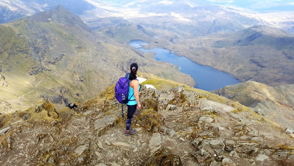
Miners’ Track
This shorter route is around eight miles (13km) there and back but the long flat start from the Pen-y-Pass car park means you’ll have a steep climb from Llyn Glaslyn. However it’s not an overly difficult route and the walk around the three lakes of Llyn Teyrn, Llyn Llydaw and Llyn Glaslyn is beautiful. The Miners’ Track is often combined with the Pyg Track to make a circular route as both paths start and end at the Pen-y-Pass car park.
The Pyg Track
Also starting from the Pen-y-Pass car park, this is the shortest route to the summit and whilst it’s more gradual overall than the adjacent Miners’ Track it’s somewhat unrelenting. One of our favourites routes to the summit is to head up the Pyg Track and descend via the Miners’ Track offering two sets of views for the prices of one. This is a very popular Snowdon summit route particularly with ‘Three Peakers’ so you’re never likely to be alone.
Snowdon Ranger Path
Over on the West side of Snowdon on the banks of Llyn Cwellyn you’ll find the Snowdon Ranger Youth Hostel from where Victorian mountain guide John Horton (nicknamed the ‘Snowdon Ranger’) would guide tourists to the summit. The path starts fairly gradually before you reach the first zig-zags and then meanders along with great views of the summit right ahead of you. The route bears left and involves a steep but easy enough scramble through another set of zig-zags before levelling out as you join the Llanberis Path at Bwlch Glas. The Snowdon Ranger path is around eight miles.
Rhyd Ddu Path
Starting from the small village of the same name, the Rhyd Ddu path is a relatively easy one to follow but the exposed, steep, rocky ground near the top make it more of a challenge than the less tough Pyg/Miners’ Tracks. Taking a positive from this however means it’s much quieter than the other routes and it’s just seven miles.
Watkin Path
Unusually named after an English politician, the scenic Watkin Path is a walk of two halves. It starts by meandering north from Nant Gwynant on the A498 through beautiful woodland, past the Rhaeadrau Waterfalls and up to an abandoned quarry before turning into a long, steep uphill slog to Bwlch Ciliau where you get a few hundred metres of flat-ish respite before an even tougher uphill scree climb. You do have the pleasure of seeing the summit in the distance for much of the second half of the walk and the final ‘climb’ to the top really makes you feel like you’ve earned your ascent. Starting the closest to sea level of all the routes at just 60m, the Watkin Path has the most ascent of all the Snowdon paths. It’s a little under eight miles (12.9km) up and down.
Crib Goch
Technically not one of the main six paths and definitely only for the bravest and those with a head for heights. Crib Goch is an exposed, grade one scramble so you’ll need to use your hands to help you along the ridge and over the pinnacles. You’ll start along the Pyg Track from Pen-y-Pass before turning off and heading up on to Crib Goch itself on this amazing adventure. You’ll still only need around six to eight hours but with large drops from either side of the ridge this is not a route for beginners. That being said this is one of our favourite routes and if you’d like to challenge yourself, join our Crib Goch and The Snowdon Horseshoe events or book a MountainXperience guide to guarantee your best mountain day ever!

